Friday 1100 Latest NHC advisory on TD #4: "The depression is forecast to become a remnant low or degenerate into a open wave tonight.
Td no 4 still holding its own fighting dry air.. here is the latest from the national hurricane center
BULLETIN
Tropical Depression Four Advisory Number 6
NWS National Hurricane Center Miami FL AL042017
500 AM AST Fri Jul 07 2017
...DEPRESSION MOVING QUICKLY ACROSS THE CENTRAL TROPICAL ATLANTIC...
SUMMARY OF 500 AM AST...0900 UTC...INFORMATION
----------------------------------------------
LOCATION...15.0N 48.8W
ABOUT 835 MI...1340 KM E OF THE LESSER ANTILLES
MAXIMUM SUSTAINED WINDS...30 MPH...45 KM/H
PRESENT MOVEMENT...WNW OR 285 DEGREES AT 22 MPH...35 KM/H
MINIMUM CENTRAL PRESSURE...1011 MB...29.86 INCHES
WATCHES AND WARNINGS
--------------------
There are no coastal watches or warnings in effect.
DISCUSSION AND 48-HOUR OUTLOOK
------------------------------
At 500 AM AST (0900 UTC), the center of Tropical Depression Four
was located near latitude 15.0 North, longitude 48.8 West. The
depression is moving toward the west-northwest near 22 mph (35 km/h)
and this general motion is expected to continue through Saturday.
Maximum sustained winds are near 30 mph (45 km/h) with higher gusts.
Little change in strength is forecast today, with weakening expected
to begin by late tonight. The depression is forecast to degenerate
into a remnant low or tropical wave by Saturday.
The estimated minimum central pressure is 1011 mb (29.86 inches).
HAZARDS AFFECTING LAND
----------------------
None.
NEXT ADVISORY
-------------
Next complete advisory at 1100 AM AST.
Saturday July 7
Sunday July 8

The July 11st one could get closer but, maybe does not matter


Tuesday
Wednesday
Thursday
Anna and Garry, prepairing with Richard to bring this boat to IJmuiden, the Netherlands..
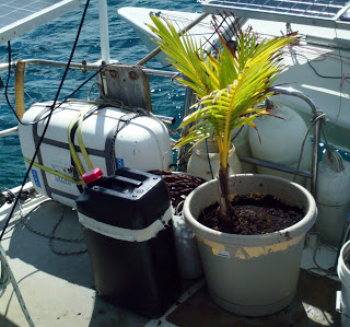
Time to say goodbye, Sophie is getting to big,
and is kept short by the blades of the wind generator...
http://teamhan.blogspot.com/2012/10/sophie-bigger-pot.html
Nov 2011, 15usd.. I tried 2ce to to get Palm tree growing from Coconut, but every time the green coming up was about 10cm high it perished..
I gave up when I could buy Sophie on Bonaire for 15us from Venezualan 'green' market at Kralendijk, near Wattaburger place..


No comments:
Post a Comment