Wednesday morning..
All is clear now.. no problems
Tuesday morning..
Wave from Africa showed potential, but now it has disappeared sort of, and now something comes behind it.. Nothing special..
Even thinking of sailing through it down south to have some more wind..
😎
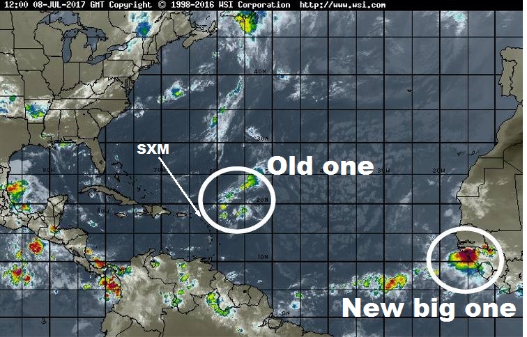
Monday morning...
Couple spots to kinda watch. Old TD #4 is still firing and trying hard
to get some circulation. Not interesting for us..
A wave out in the deep Atlantic still
at 20% from the NHC this AM. GFS going bonkers over it... others not
much at all. Wave is there... conditions not that bad... so always a
shot as it heads west. Many days to watch and see if it develops.
Whatever it is should reach the Lesser Antilles Friday'ish.
Bottom line
nothing too concrete on these... just areas to keep an eye on.
www.spaghettimodels.com / Mikes Weather Page APP
Sun morning
Still getting ready for Monday evening departure, just in case..
To Bonaire would be 475nm.. under spi 6knx24= 150nm a day.. 3 days..
Sunday morning prediction for Sat 15th 1400.. To close for comfort....?
.........
Sat evening
And suddenly predictions are.. its smaller/less violent and .. no problems here in SXM
..............
Sat morning
Old
TD #4 still shooting off some showers but no problems...
The big one off Africa is next. GFS has been all over it... EURO off
and on.
First step is surviving the big jump onto water.
Timing has whatever it becomes nearing the
Lesser Antilles later into next week. www.spaghettimodels.com/
0800 (on 8 July) predictions.. for Friday 1700..
So if it stays down we are good here in SXM.. But shit mostly goes up, where we are... Ready to go
Wednesday 1100
Thursday 13th 1100
Friday 14 1700